
Tedeschina Tower

Immagine per l'APP
Torre Tedeschina
Categoria/Sottocategoria
macrocategoria
Descrizione

The Tedeschina Tower is located on the western side of the Castello district.

Built in the early 14th century, it was named after a group of German mercenaries that lived in the ancient stronghold of Castel di Castro.

Restored in 1376 after the siege of Marianus IV of Arborea, during the sixteenth century it was incorporated by Rocco Cappellino in the Concezione bastion. During these works, the tower, which originally was between 10 and 12 meters high, was lowered.

The bricks testify to the restoration works that took place over the centuries.

Indirizzo
Via Fiume
Poligono GEO

Torre Tedeschina

Torre Tedeschina

Via Fiume

Fascia età
Fuori Cagliari
No
Quartiere
usato per affollamento
No
da usare solo per eventi e percorsi
Off
Comune
Immagine per il Portale
Torre Tedeschina

Add new review

Your review will be visible after approval by the editors

To post a review you must be an authenticated user.
Log in with Social Login

Beach Tower

Immagine per l'APP
Torre Spagnola o di Mezza Spiaggia
Categoria/Sottocategoria
macrocategoria
Descrizione

The Spanish Tower, also known as Torre di Mezza Spiaggia (Tower of half-beach), is located along the beach of Poetto, not far from the structure of the former Marine Hospital, in the Municipality of Cagliari.

Its construction dates back to the 16th century, when the Spaniards decided to fortify the entire coast of Sardinia to protect themselves from raids from the sea.

The other Towers are: the Poetto’s tower and the Saint Elia’s tower, on the Devil's Saddle, then westwards; while looking east we find the Tower of Carcangiolas (now reduced to ruin), and the Tower of Foxi, the Tower of Cala Regina and the Tower of Su Fenugu in the locality of Torre delle Stelle.

In the Spanish era, almost all of these towers, with clear skies, were easily visible from each other, making communication between them easy and timely in the event of attacks by raiders.

The structure of the Torre di Mezza Spiaggia is in limestone, truncated-conical in shape, with a height of about eight meters and a small terrace which was accessed from the inside.

Indirizzo
Spiaggia del Poetto - pressi vecchio Ospedale Marino
Poligono GEO

Torre Spagnola o di Mezza Spiaggia

Torre Spagnola o di Mezza Spiaggia

Spiaggia del Poetto - pressi vecchio Ospedale Marino

Fascia età
Fuori Cagliari
No
usato per affollamento
No
da usare solo per eventi e percorsi
Off
Comune
Immagine per il Portale
Torre Spagnola o di Mezza Spiaggia

Add new review

Your review will be visible after approval by the editors

To post a review you must be an authenticated user.
Log in with Social Login

Franca Tower

Immagine per l'APP
Torre Franca
Categoria/Sottocategoria
macrocategoria
Descrizione

The Tower Franca (or Tower Passarina), with its twin Tedeschina, closed the north front of Castello. Today it is visible, only partially, in Arsenale Square, on the right side of the Palace of the Seziate, and in Buoncammino Avenue, on the left, turning from Porta Cristina.

Built in the sixteenth century, it was used as a tower of ammunition but, in 1575, due to the modified defensive needs, it was lowered and absorbed, together with the Tedeschina, in the Bastion of the Conception; a curtain joined it to the Gate of the Capuchins (near the current Cristina’s Gate), giving rise to what would later become Arsenale Square.

Towards the end of the seventeenth century, the Palace of the Seziate was built in the space until then occupied by the curtain wall and, in 1839-40, the Palace, shortly before raised above one floor, ended up incorporating the tower, then renamed Torrione delle Seziate.

In the 1980s it was also the subject of the restoration that affected Arsenale Square, following which you can now access the interior of the Seziate curtain to admire the intact wall face of the tower.

The upper part of the tower now houses some offices of the BAPSAE Superintendency of the Provinces of Cagliari and Oristano.

Indirizzo
Viale Buoncammino
Poligono GEO

Torre Franca

Torre Franca

Viale Buoncammino

Fascia età
Fuori Cagliari
No
Quartiere
usato per affollamento
No
da usare solo per eventi e percorsi
Off
Comune
Immagine per il Portale
Torre Franca

Add new review

Your review will be visible after approval by the editors

To post a review you must be an authenticated user.
Log in with Social Login

St. Lucy Tower

Immagine per l'APP
Torre di Santa Lucia
Categoria/Sottocategoria
macrocategoria
Descrizione

Remaining part of a 14th century defensive structure, later partially incorporated into St. Lucy's church (15th century).

Indirizzo
Via Martini
Poligono GEO

Torre di Santa Lucia

Torre di Santa Lucia

Via Martini

Fascia età
Fuori Cagliari
No
Quartiere
usato per affollamento
No
da usare solo per eventi e percorsi
Off
Comune
Immagine per il Portale
Torre di Santa Lucia

Add new review

Your review will be visible after approval by the editors

To post a review you must be an authenticated user.
Log in with Social Login

St. Elia Tower

Immagine per l'APP
Torre di Sant'Elia o Lanterna
Categoria/Sottocategoria
macrocategoria
Descrizione

The Tower of Saint Elia, also called the Lantern’s Tower, was built in 1282 by the Pisans on commission of Bondo Camulitano and Colo Frapano, castellans of the Castrum of Cagliari in that time.

It is located on the top of the Saint Elia’s promontory, near the church erected in honour of Elia, and made it possible to control all the sea space in front of it, ensuring visual connection with the other towers built along the coast of the gulf.

Manned by two guardians (later called "torrieri" during the subsequent Royal Administration of the Towers) it served as a lighthouse and guard tower.

A seventeenth-century manuscript describes the need for the timely identification and reporting of the Genoese canal which, at that time, frequently crossed those waters threateningly. It seems that the subject of the inspections of the time was, among other things, the quantity of wood collected and stored near the tower.

In this place, signalling fires were kept lit with which the Castrum of Cagliari - still without the Towers of the Eagle, of the Elephant and of the Lion - had to be alerted to the presence of the enemy ship. In addition to the defensive military function, the tower was designed to signal the right route to the boats to follow to reach the port. It was decommissioned in the late 18th century after the French landing attempt (1793/94).

Currently the tower is in a very bad state of conservation.

Indirizzo
Sella del Diavolo
Poligono GEO

Torre di Sant'Elia o Lanterna

Torre di Sant'Elia o Lanterna

Sella del Diavolo

Fascia età
Fuori Cagliari
No
Quartiere
usato per affollamento
No
da usare solo per eventi e percorsi
Off
Comune
Immagine per il Portale
Torre di Sant'Elia o Lanterna

Add new review

Your review will be visible after approval by the editors

To post a review you must be an authenticated user.
Log in with Social Login

St. Pancras Tower

Immagine per l'APP
Torre di San Pancrazio
Categoria/Sottocategoria
macrocategoria
orari
chiusura
Giorno/i di apertura
Descrizione
Temporarily closed for restoration works.
in data singola
No
Descrizione

At the beginning of the fourteenth century, Pisa, in response to the threatening Aragon rise in the Mediterranean Sea, erected impressive towers in order to reinforce its stronghold in the south of Sardinia. Designed by the Sardinian architect Giovanni Capula, the Elephant Tower and the St. Pancras Tower were praised for their uniqueness, and, in 1535, Charles V, the powerful sovereign of the Holy Roman Empire, included them among the best military works of the entire Europe.
Finished in 1305, with its walls of thick limestone blocks, its narrow loopholes  and its  heavy gates, the St. Pancras Tower protected  the northern side of Castello; placed a hundred  metres above the sea level, built on four levels with a total height of more than thirty-six metres, it was also a perfect lookout station against attacks from both the sea and the hinterland.
In the sixteenth century the tower was used as a prison, where convicts lived in inhumane conditions.
The St.Pancras Tower is one of the most recognisable figures in Cagliari's landscape.
 

Indirizzo
Piazza Indipendenza
Poligono GEO

Torre di San Pancrazio

Torre di San Pancrazio

Piazza Indipendenza

Fascia età
Fuori Cagliari
No
Quartiere
usato per affollamento
No
da usare solo per eventi e percorsi
Off
peso
Comune
Immagine per il Portale
Torre di San Pancrazio

Add new review

Your review will be visible after approval by the editors

To post a review you must be an authenticated user.
Log in with Social Login

Calamosca Tower

Immagine per l'APP
Torre di Calamosca o dei Segnali
Categoria/Sottocategoria
macrocategoria
Descrizione

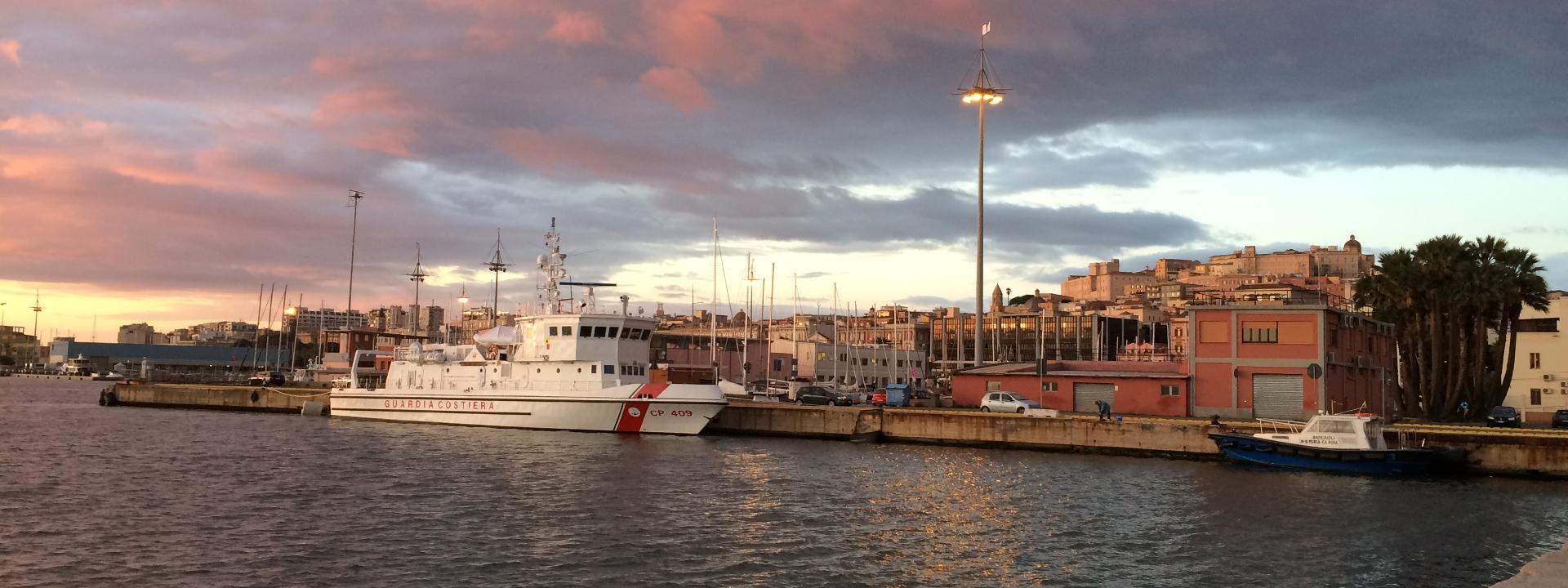
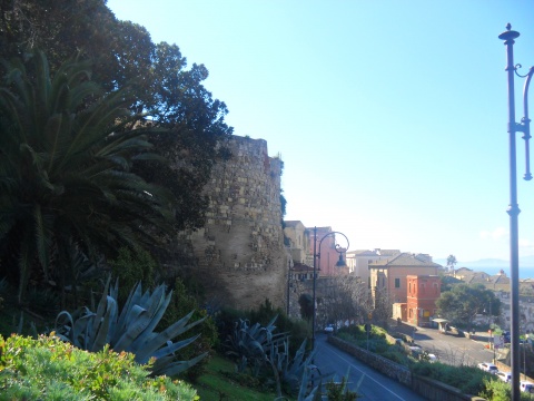
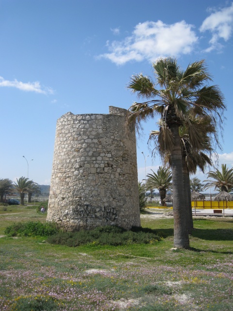
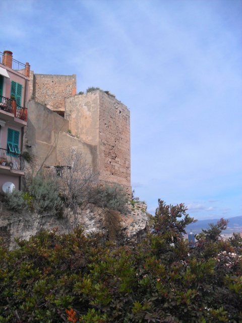
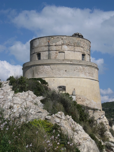
Situated in the locality of Calamosca, in Cagliari, it was a sighting and light defence tower, senzilla, consisting of two overlapping volumes, one with a truncated cone and one with a cylinder. It communicated with almost all the towers of the Gulf of Cagliari, except those of the Poetto, Mezza Spiaggia, Carcangiolas and Foxi.

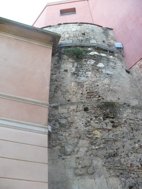
The masonry, made of calcareous material, has a base thickness of about 3.6 m. The cylindrical part, the result of subsequent restorations, is made of brick and stone and occupies the place of the original parade ground. The entrance, located about 5 m high and oriented towards the north-west, is now walled up; the tower is accessed by a new opening created at the level of the land. From the main room, with a domed vault, you reach the upper floor, also covered by a dome, through a staircase carved into the wall thickness.

Built in 1638, it is called the Tower (or Station) of the Signals because of an ingenious signalling device that allowed it to communicate with the Castle of Cagliari. The upper cylinder did not appear in the tower design, which seems to date back to a subsequent intervention in the mid-nineteenth century, in which a further expansion of the entire complex was carried out. This operation, in addition to changing the volumes, also made important changes to the internal distribution: on the first floor, in fact, four loopholes were made and habitable rooms were created.

Having become a barracks, the tower has always remained in use and is overall in excellent condition, except for a slight deterioration of the surfaces.

Indirizzo
Capo Sant'Elia - pressi Faro S. Elia
Poligono GEO

Torre di Calamosca o dei Segnali

Torre di Calamosca o dei Segnali

Capo Sant'Elia - pressi Faro S. Elia

Fascia età
Fuori Cagliari
No
usato per affollamento
No
da usare solo per eventi e percorsi
Off
Comune
Immagine per il Portale
Torre di Calamosca o dei Segnali

Add new review

Your review will be visible after approval by the editors

To post a review you must be an authenticated user.
Log in with Social Login

Elephant Tower

Immagine per l'APP
torre elefante
macrocategoria
prezzi
prezzo
€3.00
Descrizione
Full price ticket
prezzo
€2.00
Descrizione
Reduced price ticket (students under 26 y.o., visitors over 65 y.o. and groups of at least 15 people)
prezzo
€1.00
Descrizione
Reduced price for schoolchildren
prezzo
€8.00
Descrizione
COMBINED TICKET CULTURAL SITES: ROMAN AMPHITHEATRE, CRYPT OF SANTA RESTITUTA, THE VIPER'S CAVE, ELEPHANT TOWER, COVERED WALKWAY AND SPERONE GALLERY VALID FOR 1 WEEK.
Descrizione
Free admission for people with disabilities and their carers (NB: the tower has no ramps to provide disabled access), for tour guide
Descrizione
For safety reasons, children under 12 years old are not allowed to visit the tower.
orari
chiusura
Giorno/i di apertura
Descrizione
TEMPORARILY CLOSED TO THE PUBLIC.
in data singola
No
chiusura
Giorno/i di apertura
in data singola
No
chiusura
Giorno/i di apertura
Data da - a
-
dalle
10:00 am
alle
01:00 pm
Giorno da
Giorno a
Descrizione
Guided tours every hour from 10.15 am
in data singola
No
chiusura
Giorno/i di apertura
dalle
03:00 pm
alle
07:00 pm
Giorno da
Giorno a
Descrizione
Guided tours every hour from 3.15 pm
in data singola
No
chiusura
Giorno/i di apertura
Data da - a
-
dalle
10:00 am
alle
05:00 pm
Giorno da
Giorno a
Descrizione
Guided tours every hour from 10.15 am
in data singola
No
chiusura
Giorno/i di apertura
in data singola
No
Descrizione

At the beginning of the fourteenth century, Pisa, in response to the threatening Aragon rise in the Mediterranean Sea, erected impressive towers in order to reinforce its stronghold in the south of Sardinia. Designed by the Sardinian architect Giovanni Capula, the Elephant Tower and the St. Pancras Tower were praised for their uniqueness, and, in 1535, Charles V, the powerful sovereign of the Holy Roman Empire, included them among the best military works of the entire Europe.

Completed in 1306-1307, with its walls of thick limestone blocks, its narrow loopholes and its  heavy gates, the Elephant Tower protected the south-western side of Castello; developed on four levels with a total height of more than thirty metres, it was also an excellent lookout station against any possible attack from the sea.

Even today it is one of the most striking accesses to Castello, while in the past it was also used as a powder magazine, armoury and prison.

In comparison to the St. Pancras Tower, the Elephant Tower is more well-refined and it is also decorated by the marble statue of an elephant, exposed on the facade, perhaps a symbol of the  Pisan maritime power.
Restored to its original appearance, nowadays the Elephant Tower is open to visitors, by the entrance at the right side of the church of St. Joseph.

Visitors are allowed to climb up to the fourth floor. The summit of the tower is not open to the public.

Indirizzo
Via Santa Croce, snc (angolo via Università)
Poligono GEO

Torre dell’Elefante

Torre dell’Elefante

Via Santa Croce, snc (angolo via Università)

Fascia età
Fuori Cagliari
No
Quartiere
usato per affollamento
No
da usare solo per eventi e percorsi
Off
telefoni
Indirizzi email
info.beniculturalicagliari@gmail.com
Comune
Immagine per il Portale
torre elefante

Add new review

Your review will be visible after approval by the editors

To post a review you must be an authenticated user.
Log in with Social Login

Quarta Regia Tower

Immagine per l'APP
quarta regia
Categoria/Sottocategoria
macrocategoria
Descrizione

It is called “Torre della Quarta Regia” because, under the government of the Crown of Spain, and until 1954, a tax corresponding to a quarter of the catch was collected there, first by payment in kind and then by a cash payment.

Also known as Torre della Scafa, it was a watchtower manned by two men that had existed since at least 1598.

The structure was seriously damaged by a storm in November 1898 and it was later rebuilt with significant rearrangements and adjustments. Originally it was truncated cone-shaped with dimensions similar to those of other contemporary towers located in the Gulf of Cagliari, while the current shape is cylindrical with reinforced concrete floors to obtain two small rooms on which some windows for lighting have been inserted. A spiral staircase connects the two levels of the tower and allows access to the terrace. On the upper part of the facade there is a brick frieze. The height of the tower exceeds 8 meters for a diameter of 4.4 meters. The building, owned by the Autonomous Region of Sardinia, has undergone further restoration, which was completed at the end of 2017 by the Regional Coastal Conservation Agency.

Indirizzo
Viale Pula - Via dei Calafati, Loc. Sa Scafa
Poligono GEO

Torre della Quarta Regia

Torre della Quarta Regia

Viale Pula - Via dei Calafati, Loc. Sa Scafa

Fascia età
Fuori Cagliari
No
usato per affollamento
No
da usare solo per eventi e percorsi
Off
Comune
Immagine per il Portale
quarta regia

Add new review

Your review will be visible after approval by the editors

To post a review you must be an authenticated user.
Log in with Social Login

Prezzemolo Tower

Immagine per l'APP
Torre del Prezzemolo
Categoria/Sottocategoria
macrocategoria
Descrizione

"The Tower of Parsley” is located just outside the village of Sant'Elia. It can be reached by car by following the dirt road, or along Calamosca Avenue and then continue on foot in the direction of the tower.

The tower is part of the main works on the coastal fortifications in Sardinia, it guarded the beach below and the Lazzaretto area, to report any incursions towards the salt pans. It was also in visual contact with the nearby towers of Calamosca, Cala Fighera, Sant'Elia and the fortifications of Cagliari. Being about 34 m above sea level, it had an optical range of about 23 km.

The tower varied various denominations over the centuries, starting with the toponym "Capo Bernat" or also "Cala Bernat" or "San Bernardo" in Spanish times. In the eighteenth century it was called "di Santo Stefano detta del Lazzaretto", "de la Prajola" (of the beach), "Vecchia" in the twentieth century. The current name "del Prezzemolo" or "de su Perdusemini" or "Petro Semolo", already attested in the XVIII-XIX century, is actually borrowed from the tower of Cala Fighera, according to a 1740 document.

The construction of the tower at Capo Bernat dates back to 1578, when there was also the one of Calamosca, and they were both controlled by the city of Caller. But already in 1597, the Capo Bernat tower was restored. At the time, the garrison consisted of two towers. A further restoration was done in 1605, when a hanging balcony was placed in the entrance. In 1606 and 1615 the garrison was increased.

The “Torre del Prezzemolo” is a construction with a classic trunk shape but with reduced dimensions. Among the coastal towers it is the smaller one, with a foundation diameter of just 4.5 m and a residual height of 11 m. This is due to the site where it was built, a rocky outcrop with access from a single direction, close to the cove below.

The tower, intended only for the sighting function, was called "torrezilla".

In 1638, when the nearby Tower of Calamosca came back into operation, the Torre del Prezzemolo was discharged and no longer appears in the official documents of the 17th and 18th centuries. Although a Torre del Lazzaretto appears in the report of Cagnoli, the Commissioner of Artillery, Factories and Fortifications, in 1720. However, only in 1772 was it rearmed as a post for riflemen and as support for a light infantry company.

In 1793, on the occasion of the French attack, the engineer Lorenzo arranged a small battery of cannons behind the tower, thanks to which the landing on the beach below was avoided. After this episode, however, the tower was definitively abandoned.

It was restored only in December 1916 and in 1967 the rock on which it stands was propped up, to avoid its flaking.

Indirizzo
Via Borgo Sant'Elia
Poligono GEO

Torre del Prezzemolo o di Cala Bernat

Torre del Prezzemolo o di Cala Bernat

Via Borgo Sant'Elia

Fascia età
Fuori Cagliari
No
Quartiere
usato per affollamento
No
da usare solo per eventi e percorsi
Off
Comune
Immagine per il Portale
Torre del Prezzemolo

Add new review

Your review will be visible after approval by the editors

To post a review you must be an authenticated user.
Log in with Social Login