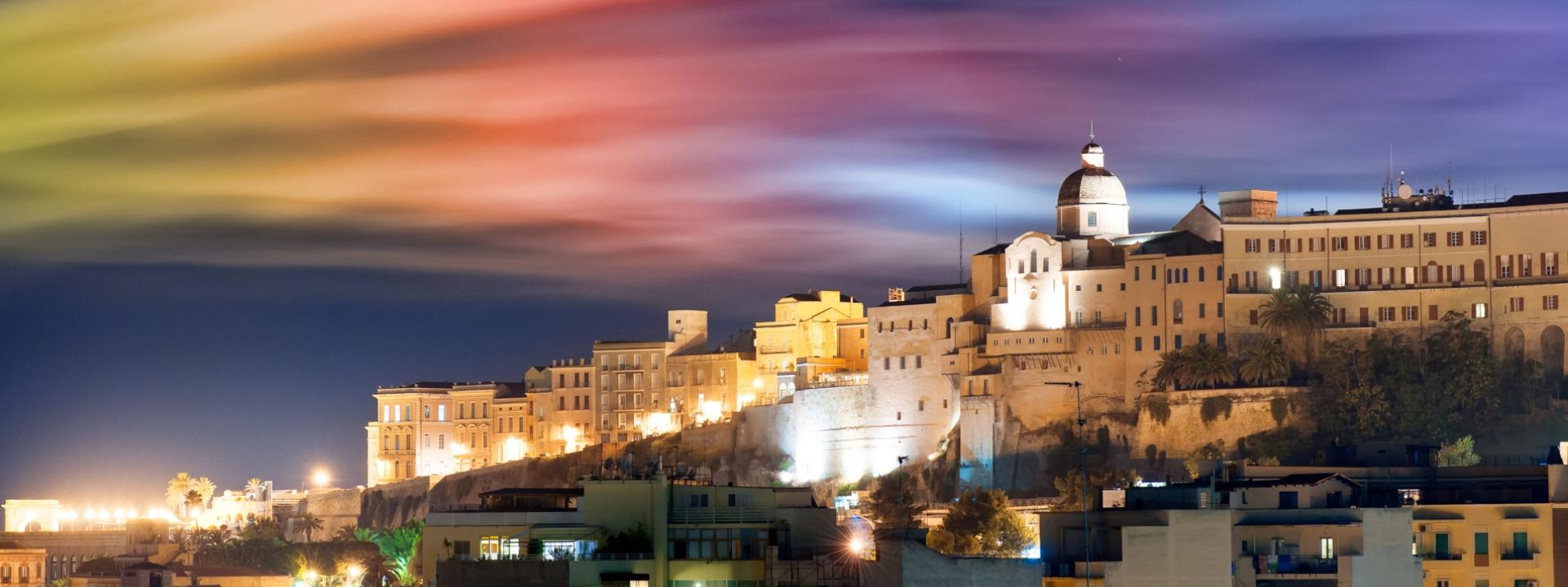
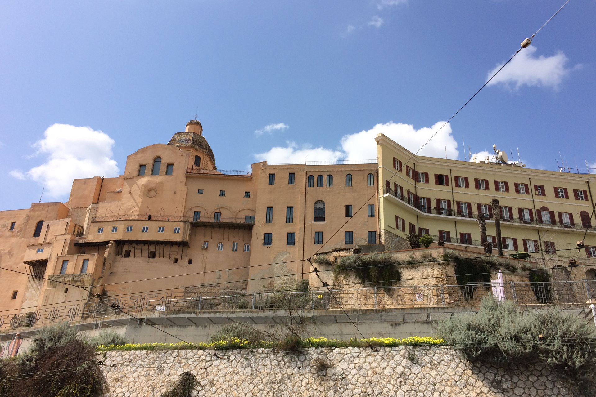
Castello district

Immagine per l'APP
Quartiere Castello
Categoria/Sottocategoria
macrocategoria
Descrizione

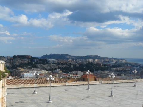
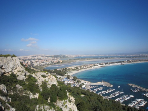
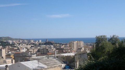
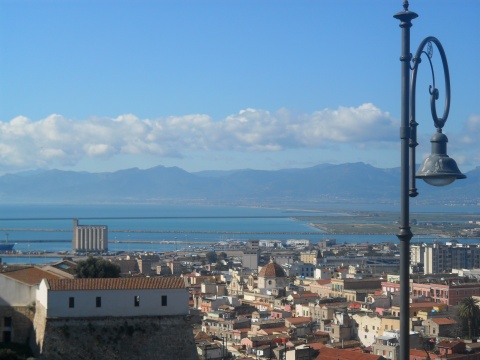
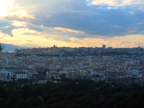
Castello (Casteddu de Susu in Sardinian, in Italian Castello Superiore) is the main of the four historic districts of the city of Cagliari. It rises in a predominant position, on a limestone hill, about one hundred meters above sea level.

The district was founded in the thirteenth century by the Pisans, who fortified it, providing it with walls, towers and bastions and transferred the headquarters of civil, military and religious power from the Judicial capital of Santa Igia, which they themselves had previously destroyed, decreeing the end of the Giudicato of Càlari.

Since then, under every domination, from the Pisan (XIII - XIV century), to the Aragonese-Spanish (XIV - XVIII century) and Piemontese (XVIII - XIX century), up to the second post-war period, the Castello district hosted the palaces of the power and noble residences, so as to identify with the city itself, which, in fact, in Sardinian is called Casteddu. The neighbourhood is still accessed through the ancient medieval gates, open in the walls that still surround most of the perimeter of the Castle, isolating it from the rest of the city.

The walls that run around the perimeter of the ancient Castello district include the Elephant tower and that of San Pancrazio.

The Castle currently houses important institutions, such as the Prefecture and the Council Hall of the Metropolitan City of Cagliari in the premises of the Royal palace, located in Palazzo Square.

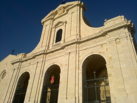
The Parish of Castello is dedicated to Saint Cecilia and has its seat in the Cathedral Church, the main church of the Archdiocese of Cagliari, also in Palazzo Square.

The University of Cagliari also has its headquarters in the Castle, in the eighteenth-century building which houses the offices of the Rectorate.

The Castello district offers various reasons for a visit, both for the numerous historical and artistic testimonies that are found there, and for perhaps the most suggestive places, which are found along the narrow streets, the stairs, the small squares that open, like terraces , on beautiful views and overlook the dark hallways of the buildings, once sumptuous noble residences and today often with decadent charm.

By visiting the churches that are not even visible from the outside, you will notice interesting works of art inside them.

The Castello district is composed of civil and military architecture: fortifications such as towers, the Elephant Tower with the access door to the neighbourhood from Stampace; the Tower of Saint Pancrazio; the Tower of the Eagle, also from the beginning of the 14th century, incorporated today in the Boyl Palace, still constitutes an access to Castello from the south, from the Marina district, via the “Arcade of the Graces”.

In addition there are the Bastion of Saint Remy, which, through its monumental staircase, directly connects Castello and Villanova and incorporates the ancient Bastions of the Mint and Saint Caterina’s; The former Saint Carlo’s barracks, an area known as the "Jewish Ghetto"; the Buoncammino Prison, the district house of the city throughout the twentieth century, until the end of 2014; the historic buildings of the main Sardinian authorities and noble families, including: the Palazzo Regio; the former City Palace; The Archiepiscopal Palace; the “Palazzo delle Seziate”, the University Palace; the Conservatory of the Daughters of Providence, formerly a college for nobles and in the nineteenth century the seat of a charitable institution for orphans, its large neoclassical facade dominates the east side of  Independence Square, abandoned since the end of the twentieth century; the Boyl Palace.

There also are numerous elements that make up religious architecture: Square Palace, view of the Cathedral, with the neo-Romanesque facade and the imposing thirteenth-century bell tower. There are currently seven churches in the district: the cathedral church; four churches of Castello, built in the 16th century, which testify to the Aragonese Gothic style: the church of the Purissima; the church of Santa Lucia; the church of the Madonna della Speranza, noble chapel of the Aymerich marquis of Laconi; the church of Saint Maria del Monte, formerly the oratory of the oldest confraternity in Cagliari, dissolved in the 19th century, now the seat of the military Sovereign Order of Malta.

In Baroque style, however, we have: the basilica of Saint Croce, of the Order of Saints Maurizio and Lazzaro and the church of Saint Giuseppe Calasanzio, formerly the church of the Piarists.

Some remains of the church of the monastery of Saint Caterina are still preserved, destroyed at the end of the 19th century to make room for the present elementary school of the same name. Under the school building, the crypt of the monastery should still be found, where the nuns used to bury the deceased sisters. Not far away, under the pavement of the terrace of the bastion of Saint Caterina, following recent excavations for maintenance works, rooms have been found, probably referable to a church building dating back to the thirteenth century.

Finally, we recall the two vast complexes of the Jesuit College, at the Basilica of Holy Cross, an eighteenth-century building partly used today by the Faculty of Architecture of the University of Cagliari and the “College of the Scolopi”, a nineteenth-century building now home to the State Art School.

Most of the museums of Castello and Cagliari itself are currently housed in the premises of the modern museum complex known as the Citadel of Museums; in this complex of constructions, built in the seventies of the twentieth century on the area that hosted the Royal Arsenal, there are:

    The Archaeological Museum.

    The National Picture Gallery.

    The Clemente Susini Museum of Anatomical Waxes.

    The "Cardu" Museum of Siamese Art.

Furthermore, the Citadel of Museums organizes interesting temporary exhibitions and other cultural events.

In addition, in the renovated rooms of Fossario street, near the Cathedral, there is the Museum of the Cathedral, which houses the Treasury of the Cathedral, while the Sardinian Luigi Piloni Collection is housed in the University Palace.

Enchanting and fascinating there are numerous streets and squares not to be missed, both for their historical-artistic value and because they are part of the famous shopping streets.

Indirizzo
Quartiere Castello
Poligono GEO

Quartiere Castello

Quartiere Castello

Quartiere Castello

Fascia età
Fuori Cagliari
No
Quartiere
usato per affollamento
No
da usare solo per eventi e percorsi
Off
peso
Comune
Immagine per il Portale
Quartiere Castello

Add new review

Your review will be visible after approval by the editors

To post a review you must be an authenticated user.
Log in with Social Login

Bonaria district

Immagine per l'APP
Quartiere Bonaria
Categoria/Sottocategoria
macrocategoria
Descrizione

The Bonaria district is located on the homonymous hill and in its surroundings, in the south-eastern part of the town of Cagliari.

The neighbourhood is enclosed by Sonnino street, Grazia Deledda, Pessina and Pineta, by the New Median Scrolling Axis and, to the south, it extends to the sea (beach and small port of Su Siccu).

Human settlements in the Bonaria area date back to the Punic, as evidenced by the necropolis found on the hill, which was later reused by the Romans and then transformed into a quarry.

During the Middle Ages the church of San Bardilio was built, in Romanesque-Pisan and Italian Gothic style. The church doesn’t longer exist today, since, following abandonment and structural degradation, it collapsed in 1909 and was definitively demolished 20 years later.

In 1324, on the top of the Bonaria hill, the Aragoneses built a fortified citadel, which was the first capital of the Kingdom of Sardinia for two years and which was used for the siege of Castel di Castro (the current Castello district). At the time, the location was renamed Buen Ayre (good air), then Italianized in Bonaria.

The chapel of the fortified citadel was later transformed into a Marian sanctuary and next to the fourteenth-century church, still in existence, the Basilica of Our Lady of Bonaria was later built, which in addition to being the main Marian sanctuary of Sardinia, is also one of the monuments more impressive and spectacular not only in the neighbourhood but in the whole city of Cagliari. A beautiful park has also been created behind the Basilica and on the slopes of the Bonaria hill, also known as a panoramic point.

Next to it is the nineteenth-century monumental cemetery of Bonaria. Built on a part of the ancient Phoenician-Punic necropolis, it still houses the burials of numerous illustrious Cagliari’s citizens.

The residential part of the Bonaria district has developed around the hill and on part of it, becoming a densely populated but quiet and elegant area. The street that crosses the neighbourhood, Milano street, is composed of fine villas which, from the early 1900s, began to be the residences of the Cagliari upper middle class, and from more popular but well-built buildings, with architectural styles ranging from deco to the neo medieval, from the eclectic to the rationalist.

The houses are surrounded by gardens and large green spaces, crowded with tall trees (note is the beautiful flowering of the jacarandas in spring and autumn), creepers and flowers of all kinds.

The Bonaria district is also one of the economic, tourist and administrative centers of Cagliari: there are important banking and insurance offices, prestigious hotels, numerous bed & breakfasts, sports facilities and the Trade Fair District (Sardinia International Fair).

Finally, in “One hundred thousand’s” square, at the foot of the Bonaria staircase, the Campagna Amica market is held every Thursday, with the direct sale by the producer to the consumer of the agricultural and food and wine products from the countryside of the province of Cagliari.

Indirizzo
Quartiere Bonaria
Poligono GEO

Quartiere Bonaria

Quartiere Bonaria

Quartiere Bonaria

Fascia età
Fuori Cagliari
No
Quartiere
usato per affollamento
No
da usare solo per eventi e percorsi
Off
peso
Comune
Immagine per il Portale
Quartiere Bonaria

Add new review

Your review will be visible after approval by the editors

To post a review you must be an authenticated user.
Log in with Social Login

B&B Qaral

Categoria/Sottocategoria
prezzi
prezzo da
€40.00
prezzo a
€50.00
Descrizione
Double Room single use
prezzo da
€65.00
prezzo a
€80.00
Descrizione
Double Room
orari
chiusura
Giorno/i di apertura
Descrizione
H 24
in data singola
No
Descrizione

Qaral Bed & Breakfast is conveniently located in Cagliari’s historic centre, a few minutes walk from the city’s most renowned monument, Saint Remy’s Bastion, from the late XIX century. 

The area around Qaral B&B is well served by public transports and close to the taxi stop in Piazza Costituzione. Buses quickly connect to the Poetto beach (one of the Europe’s longest beaches,10 km).

If you’re up for some shopping, Qaral B&B is in an ideal location: the nearby pedestrian streets – via Garibaldi and via Manno – offer a wide array of shopping choices.

And as you get hungry, the area is provided with lots of quality restaurants where you can have a taste of Cagliari’s and Sardinia’s cuisine.

The rooms of Qaral B&B are fully furnished with private air-conditioner, desk, WiFi internet connection, bed linen, shared fridge, private en-suite bathroom with shower, hair-dryer, towels and shampoo.

Rooms are daily cleaned, while the bed sheets are changed twice a week or at every new guest’s check-in.

Indirizzo
Vico II S. Giovannni, 1
Risorse multimediali
/sites/default/files/file_img_cagliari/la_sala_colazione_e_relax_per_sito_comune.jpg
Poligono GEO

B&B Qaral

B&B Qaral

Vico II S. Giovannni, 1

Fascia età
Fuori Cagliari
No
Quartiere
usato per affollamento
No
da usare solo per eventi e percorsi
Off
telefoni
Indirizzi email
info@qaral.it
Comune
Immagine per il Portale
Qaral bed & breakfast
Servizi offerti
Air conditioning
Old Town
Wi-FI

Add new review

Your review will be visible after approval by the editors

To post a review you must be an authenticated user.
Log in with Social Login

Terrace Umberto I viewpoint

Categoria/Sottocategoria
Descrizione

From the Umberto I terrace of the Bastione di Saint Remy you can enjoy a wonderful landscape of the city and Queen Margareth avenue. Continuing straight along Fossario’s street, on the right you can admire the Gulf of Angels, the roofs of the Villanova district, the ponds, Mountain Urpinu and the hill of Bonaria.

Proceeding straight you arrive at the Mercede Mundula square which offers a general view of the Villanova district with Mountain Urpinu in the background and on the left the Molentargius lagoon and the hinterland villages.

Indirizzo
Terrazza Umberto I
Poligono GEO

Punto panoramico Terrazza Umberto I

Punto panoramico Terrazza Umberto I

Terrazza Umberto I

Fascia età
Fuori Cagliari
No
Quartiere
usato per affollamento
No
da usare solo per eventi e percorsi
Off
peso
Comune
Immagine per il Portale
Punto panoramico Terrazza Umberto I

Add new review

Your review will be visible after approval by the editors

To post a review you must be an authenticated user.
Log in with Social Login

Devil's saddle viewpoint

Categoria/Sottocategoria
Descrizione

From the Devil's Saddle, on the promontory of Saint Elia, you can catch a spectacular view that ranges from Poetto Boulevard to Capo Carbonara and to the open sea.

It can be reached through a green path, which crosses particular areas for its archaeological, environmental, ecological and landscape values.

It is possible to identify several stopping points on which it is worth pausing and from which you can admire: in the north - north west direction, the front of the quarries (Roman origin, up to the 1900s).

The open sea, the Signal Tower with the Cala Mosca Lighthouse, the canal port, the industrial area of Macchiareddu and Cagliari itself, botanical peculiarities such as the Saint Peter’s Palm, various olive trees and junipers.

One of the most interesting points is a real natural terrace on Cagliari, the Poetto, the salt pans. On the ridge it is possible to completely observe both the view to the north, that is, the long strip of land between the sea and the salt pans that characterizes one of the Cagliari landscapes par excellence, the Poetto beach; while towards the south the view can range over the entire promontory.

The first natural element easily perceivable is the natural spur of the Devil's Saddle, then the Saint Elia’s Tower, the Poetto Tower, the ruins of the military installations of the Second World War and the remains of the monastic complex of S. Elia, where they came the martyr's relics found.

A little further on you walk in the cliff abovethe Pigeons Cave. Following the ancient Roman road system, there is the Punic cistern.

In another interesting point you can dominate the entire natural canyon, rich in Mediterranean vegetation, excavated from an ancient stream that has shaped the territory.

Finally, you can admire Cala Fighera and Cala Mosca. The entire naturalistic and archaeological path is passable by anyone who is used to walking, just having a pair of trekking shoes and a supply of water.


Indirizzo
Viale Calamosca
Poligono GEO

Punto panoramico Sella del Diavolo

Punto panoramico Sella del Diavolo

Viale Calamosca

Fascia età
Fuori Cagliari
No
usato per affollamento
No
da usare solo per eventi e percorsi
Off
peso
Comune
Immagine per il Portale
Punto panoramico Sella del Diavolo

Add new review

Your review will be visible after approval by the editors

To post a review you must be an authenticated user.
Log in with Social Login

Embankment Avenue viewpoint

Categoria/Sottocategoria
Descrizione

From Embankment Avenue you can admire the chain of roofs of the Villanova district, Mountain Urpinu and the Campidano on one side, the Devil's Saddle and the Basilica of Bonaria on the other.

The Embankment of Cagliari is a panoramic walk that runs along Queen Hellen street, a long tree-lined avenue overlooked by prestigious Liberty-style villas. It starts in Giovanni Marghinotti’s square, near the Bastion of Saint Remy and the Gardens Under the Walls, and ends at the entrance to the Public Gardens of the Municipal Art Gallery.

The walk, which runs along the walls of the historic district of Castello to the west and the housing complex of Villanova to the east, is one of the most suggestive panoramic points of the city, from which it is possible to admire some of the most significant works of local street art. It mixes the historical, architectural and artistic elements that the city offers with the shopping streets Garibaldi street and Manno street.

Indirizzo
Viale Regina Elena
Poligono GEO

Punto panoramico di Viale Terrapieno

Punto panoramico di Viale Terrapieno

Viale Regina Elena

Fascia età
Fuori Cagliari
No
Quartiere
usato per affollamento
No
da usare solo per eventi e percorsi
Off
peso
Comune
Immagine per il Portale
Punto panoramico di Viale Terrapieno

Add new review

Your review will be visible after approval by the editors

To post a review you must be an authenticated user.
Log in with Social Login

Buoncammino Avenue viewpoint

Categoria/Sottocategoria
Descrizione

Buoncammino is a tree-lined avenue that connects Weapons Square in the north and Christina's door in the south, a suggestive entrance to the Castello district, near the Saint Pancrazio Tower and the Museum Citadel. The urban green of pines, cypresses and elms is interspersed with several dining options and comfortable benches from which you can admire the landscape that dominates the whole city at 360 degrees, which goes east from Villanova to Poetto and from the pond of Molentargius to the mountains of the Seven Brothers, and west from Mountain Arcosu to Saint Gilla, and finally to the Roman amphitheatre. In the evening along Buoncammino avenue you can admire the extraordinary spectacle of the sunset over the Saint Gilla’s lagoon.

Indirizzo
Viale Buoncammino
Poligono GEO

Punto panoramico di Viale Buoncammino

Punto panoramico di Viale Buoncammino

Viale Buoncammino

Fascia età
Fuori Cagliari
No
usato per affollamento
No
da usare solo per eventi e percorsi
Off
peso
Comune
Immagine per il Portale
Punto panoramico di Viale Buoncammino

Add new review

Your review will be visible after approval by the editors

To post a review you must be an authenticated user.
Log in with Social Login

Monte Urpinu viewpoint

Categoria/Sottocategoria
Descrizione

From the top of MonteUrpinu you can enjoy one of the most beautiful landscapes of Cagliari. The view extends from the pond of Molentargius towards the east, full of pink flamingos, to the city and its port to the west.

From the terrace of Europa boulevard (100 meters above sea level), you can enjoy a unique panoramic view: Castle district with its walls, ponds, the Gulf of Angels, the Saint Benedetto’s district and the hinterland for many kilometers, up to the mount of the Seven Brothers. It is one of the most popular places during the night of Saint Laurence and in general to admire the wonder of the moon and stars in the sky. Do not miss a walk in the homonymous city park, with its ponds, children's playground and many beautiful peacocks in freedom.

Indirizzo
Viale Europa
Poligono GEO

Punto panoramico di Monte Urpinu

Punto panoramico di Monte Urpinu

Viale Europa

Fascia età
Fuori Cagliari
No
Quartiere
usato per affollamento
No
da usare solo per eventi e percorsi
Off
peso
Comune
Immagine per il Portale
Punto panoramico di Monte Urpinu

Add new review

Your review will be visible after approval by the editors

To post a review you must be an authenticated user.
Log in with Social Login

Monte Claro viewpoint

Categoria/Sottocategoria
Descrizione

The park of Monte Claro, together with the caves of the promontory of Capo Sant'Elia, is the site of the oldest human settlements in the province of Cagliari, dating back to the Neolithic period. It is one of the 7 hills of Cagliari, (7 like the hills of Rome, Istanbul and Lisbon); the other six are: Castello, Tuvumannu, Tuvixeddu, Monte Urpinu, Colle di Bonaria, Colle di San Michele.

Monte Claro  is today one of the most popular public parks in the city, especially for sports activities such as jogging, or to climb to the top of the hill through very suggestive green paths, to reach the ancient ruins and the renowned colourful rose garden, the panoramic provincial library and an area with outdoor gymnastic equipment. From this panoramic point you can enjoy a magnificent view of the city, the hinterland and the surrounding mountains. In the plain part of the park there is a large modern fountain and a pond, crossed by a pedestrian bridge, where live several geese, ducks, turtles and fish of various types and sizes. In the park there are also an outdoor theatre, a bowling alley and a play area for children. During the summer the park remains open until midnight, and cultural and entertainment events are often organized.

Indirizzo
Via Cadello
Poligono GEO

Punto panoramico di Monte Claro

Punto panoramico di Monte Claro

Via Cadello

Fascia età
Fuori Cagliari
No
usato per affollamento
No
da usare solo per eventi e percorsi
Off
peso
Comune
Immagine per il Portale
Punto panoramico di Monte Claro

Add new review

Your review will be visible after approval by the editors

To post a review you must be an authenticated user.
Log in with Social Login

Tuvixeddu viewpoint

Categoria/Sottocategoria
Descrizione

From the hill of Tuvixeddu you have a wide view of the western side of Cagliari which ranges up to Sarroch. From Bainsizza street, in the middle of the hill, you can also take a long naturalistic-panoramic walk and enjoy a beautiful landscape of the entire park and the breathtaking view of the Saint Gilla’s lagoon. The path in the upper part of the hill has two areas equipped for rest and relaxation and one for shows and events. The park is monitored and the staff provides information leaflets and maps of the area.

Indirizzo
Viale Sant'Avendrace
Poligono GEO

Punto panoramico del colle di Tuvixeddu

Punto panoramico del colle di Tuvixeddu

Viale Sant'Avendrace

Fascia età
Fuori Cagliari
No
usato per affollamento
No
da usare solo per eventi e percorsi
Off
peso
Comune
Immagine per il Portale
Punto panoramico del colle di Tuvixeddu

Add new review

Your review will be visible after approval by the editors

To post a review you must be an authenticated user.
Log in with Social Login