Alberto La Marmora Commemorative Plaque
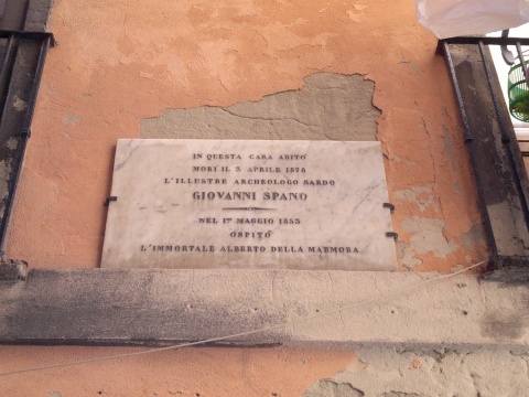
In 65, Nicolò Canelles street there is a plaque in memory of the Italian general and scientist Alberto La Marmora, who lived for a long time in Sardinia. A street in the Castello district is also dedicated to him.
Alberto Ferrero della Marmora (or Alberto della Marmora or Alberto La Marmora) born in Turin, was an Italian general, naturalist, cartographer and politician. He was the brother of three other important generals of the Kingdom of Sardinia and then of the Kingdom of Italy.
He made his first trip to Sardinia in 1819 and arrived in Cagliari after a 12-day crossing. He wanted to apply to the studies of ornithology and practice hunting. He was with prof. Keyser, a geologist from Cristiania, (today's Oslo) and the knight De Prunner, director of the Museum of natural history and antiquities in Cagliari. This first trip provided him with ample material, which he will use in his subsequent writings on Sardinia, to describe the island in all its parts. He spent most of his life back and forth between Turin and Sardinia; in 1836 he was also appointed Inspector of mines in Sardinia and, in 1841, he was entrusted with the command of the Navy School of Genoa. In 1834 was also knight of the Order of Saints Maurizio and Lazzaro.
In the Senate he always fought for the interests of the island and on 16 November 1851 he was granted Cagliari citizenship. To Sardinia he dedicated his studies in French on economic and physical matters: "Voyage en Sardaigne", published in Paris in 1826. Embellished with 19 illustrated tables by Giuseppe Cominotti and others, he expanded the studies previously conducted by Francesco Cetti, probably remaining the most famous work among the travel reports of the nineteenth century.
The text contains his observations, statistics, research on the nature and archaeological heritage of the region. The second edition of the work was even more organic as it was divided into three branches with expanded treatments. The work is divided into: "Physical and human geography of Sardinia", published in 1839; "Antiquity", published in 1840 and "Geology", published in 1857 in two volumes. The first volume begins with a compendium of ancient and modern Sardinian history, to then describe the island from a physical and climatic point of view and subsequently examines the mineral, vegetable and animal kingdom, the talk of the inhabitants, whose physical characteristics are also analysed, customs, habits and language and it concludes with a picture on the administration and economic activities of Sardinia. The second volume deals with the island's pre-Roman monuments, similar to the menhirs, and with some ancient inscriptions, with the nuraghes. Then he tries to reconstruct the geography of the island at the time of the Romans and tries to recreate the ancient road network, drawing much news from the research of other scholars, then he goes on to examine the Roman antiquities present on the island, deepening on the ancient Sardinian medals, on tombs, sarcophagi, temples, amphitheatres and theatres, and collects inscriptions from Roman temples. The third and final part of the work describes the island from a geological point of view, examining the various types of terrain and fossils from different eras and to do this La Marmora sought valuable collaborations especially for the examination of fossils and rocks becoming, of fact, a pioneer of Sardinian geology, of which he traced the basic lines. The exhibition is interspersed with anecdotes about the costumes of the inhabitants and the adventures that happened to him in his travels.
From 1851 to 1857 he made several trips to Sardinia to finish his studies.
Overall, the Count dedicated more than fifty scientific publications to Sardinia which, although they did not spread widely on the island, did so abroad, focusing attention on a land hitherto shrouded in darkness, giving it value and attracting other curious glances.
He travelled with his equipment for the districts taking notes and making topographical measurements. He was responsible for measuring the highest point of the Gennargentu, which has his name (Punta La Marmora - 1,834 meters).
In 1884 the first geographic map of Sardinia was republished in photolithographic reproduction with the title Atlas of the island of Sardinia in scale 1: 50000, made with scientific criteria, as a result of decades of work started from the nautical chart of Captain William Henry Smyth, of which Della Marmora served himself, in collaboration with the specialist Carlo De Candia, also a general.
As a scientist, he studied the seabed and the coasts close to the rivers. His studies and observations were used in the feasibility analysis of the Suez Canal. His considerations will then be taken up again by Luigi Negrelli and Pietro Paleocapa, who will have a primary role in the construction of the Canal.
Passionate archaeology investigator, in 1829 he entered the Academy of Sciences of Turin, of which he later became vice-president, and, in 1832, in the Geological Academy of Florence. He also became a member of several prestigious institutes of studies such as the Lombard Institute of Sciences and Letters in Milan, the Agricultural and Economic Society of Cagliari and the Royal Society of Naples, and a member of the Deputation of Homeland History of Turin. He obtained the diploma of the Geological Societies of France, Berlin and London and he was officially commemorated by prestigious institutions such as the Royal Geographical Society of London.
Lapide Commemorativa di Alberto La Marmora
Lapide Commemorativa di Alberto La Marmora
Via Nicolò Canelles, 65
City
CagliariAdd new review
Your review will be visible after approval by the editors
To post a review you must be an authenticated user.
Log in with Social Login